
Martin & Mandy

 Last month we showed you some of the postcards we have collected over the past couple of years and after we wrote that article we did a bit of hunting and found the spots where those postcards were originally taken, and there are some surprising changes but also some suprising similarities. You need to dig out last months copy of the Journal and put them side by side (or look on the website).
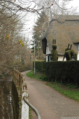
One of the few thatched buildings in Buntingford is the Pig's Nose and whilst it's been beautifully re-thatched since the photograph was taken for the postcard it still holds it character, as the original shape and features of the thatch have been kept. We're not sure of the origin of the name, but know that section of the river is on the 1740 Tithe Map - shown as the "Pigs Snout".
The building itself has an interesting history too, having started life as a barn, it became the poor house, then two dwellings and finally one dwelling as it is now. I understand that there used to be two spiral staircases within the building - so if you wanted to get from one upstairs bedroom to the one next to it you had to come down one staircase and go up the other! No doubt that has changed now. I understand that the Pig's Nose was flooded in the late 1960's - where the water rose to three feet above floor level - this is quite amazing when you see how low the river is today...
Now to my favourite postcard of St Bartholomews with it's old picket gate and fence. In this early spring picture taken recently you can see remnants of the original pathway, with the odd white post surprisingly still visible, but no gate and no fence... The avenue of Lime trees is still there - with a few trusty old originals supplemented by some up and coming youngsters! The church is sadly cloaked in hoarding and scaffolding - but this means that in a few years time the building will have been brought back from the brink of collapse and will have a new lease of life.
 Open days are going to be a bit more difficult while the building work goes on - but at least we can look forward to a time where the chancel can be open to the public again, so that we can continue to share it's history with those that are interested.
The next one is of the bridge over the River Rib, and the sign for the Jolly Sailors is still in the same spot! The chimneys in the original picture do still exist but are partially hidden behind some trees, but a whole house has disappeared from this scene and you can now see the back of St Peter's where in the previous picture only 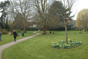
the very top of it was peeking out. St Peter's, built in the 17th Century to replace St Bartholomew's as the main church for the town, is believed to be the oldest surviving brick church in the country.
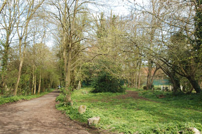
Finally Layston Park - this hasn't changed much at all - even the path follows the same route! It is now called Layston Court Gardens and these grounds originally belonged to Layston Court House, which I believe was built inthe early 17th century for Elizabeth Freeman of Aspenden as a school house.
.jpg)
The house was very visible in the originalphotograph but you can see a tree to the right of the path... Well, that little tree is now a whopperwhich hides virtually the whole house!
Some of you may have seen us around the town a little while ago taking up to date photographs to match with all the old postcards we have - all the ones we have found can be seen on the Gallery link on the first page of the Layston Church website. If you have any pictures of Layston Church hidden away please get in contact with us or the editor, as we would love to see them.
 |
|
 |